
Travellers are at a loss to determine whether the original Kabesh we read of Gen. 14. 7. is the same with the Kadesh, Num. 13. 26. And it is not clearly accounted for, wherefore Barnea was added to it. The term Kadesh means holy. Barnea is a compound of Bar, a son - - and Nuah, one who is moving about. Perhaps Barnea might have been given to Kadesh, from the frequent movings about of Israel while in the wilderness state. And in this sense the name was well - termed, and may be said of the church always on earth. Oh! thatour journeyings might be ever to Kadesh, and always as Kadesh; for surely Moses said, so in Jesus it may be said of the church now, "ye are an holy people unto the Lord thy God." (Deut. 7: 6.) It. was at Kadesh Miriam died. Here also was the memorable rebellion of Israel concerning water; and here the Lord’s grace notwithstanding that rebellion. (See Num. xx. 1 - 13. Ps. cvi. 32, 33.)
a station of the Israelites, to which they returned again after thirty-eight years, is said to be in the wilderness of Zin, Num 13:21; Num 20:1; Deu 32:51; but in the wilderness of Paran, Num 12:16. In the Itinerary it is simply called Rithmah, “the wilderness.” Dr. Hales observes, that Wells, Shaw, the authors of the “Universal History,” &c, have greatly perplexed and obscured the geography of this Itinerary, by supporting that there were two places of this name distinct from each other. They consider the latter of them as situated on the western side of Mount Hor, toward the land of Canaan, and thus confound it with that Kadesh in the land of the Philistines, where Abraham sojourned, Gen 16:13; Gen 20:1. But that it lay on the east side of Mount Hor, is evident; for why should Moses send messengers from Kadesh to the king of Edom, requesting permission to pass through his territories in the way to Canaan, if they were already at the verge of Palestine Num 20:14? This application, however, was necessary if his territories were situated between Canaan and the Israelites. The true situation of Kadesh is ascertained beyond a doubt, from its lying between Mount Hor and Ezion-Geber, on the Elanitic Gulf, Num 33:35-37.
Ka’desh-bar’ne-a. (Kadesh means holy; it is the same word as the Arabic name of Jerusalem, el-Khuds. Barnea means desert of wandering). This place, the scene of Miriam’s death, was the farthest point which the Israelites reached in their direct road to Canaan; it was also that whence the spies were sent, and where, on their return, the people broke out into murmuring, upon which their strictly penal term of wandering began. Num 13:3; Num 13:26; Num 14:29-33; Num 20:1; Deu 2:14.
It is probable that the term "Kadesh," though applied to signify a "city," yet had also a wider application to a region in which Kadesh-meribah certainly, and Kadesh-barnea probably, indicates a precise spot. In Gen 14:7, Kadesh is identified with En-mishpat, the "fountain of judgment". It has been supposed, from Num 13:21; Num 13:26 and Num 20:1 that there were two places of the name of Kadesh, one in the wilderness of Paran and the other in that of Zin; but it is more probable that only one place is meant, and that Zin is but a part of the great desert of Paran.
(There has been much doubt as to the exact site of Kadesh; but Rev. H. Clay Trumbull of Philadelphia, visiting the spot in 1881, succeeded in rendering almost certain that the site of Kadesh is Ain Kadis (spelled also Gadis and Quadis); "the very same name, letter for letter in Arabic and Hebrew, with the scriptural fountain of Kadesh -- the ’holy fountain’, as the name means -- which gushed forth when Moses smote the rock." It lies 40 miles south of Beersheba and 165 northeast of Horeb, immediately below the southern border of Palestine. It was discovered in 1842 by the Rev. J. Rowlands of Queen’s College, Cambridge, England, whose discovery was endorsed by the great German geographer Ritter, by E.S. Palmer in his "Desert of the Exodus," and by the "Imperial Bible Dictionary."
Dr. Trumbull thus describes it: -- "It is an extensive oasis, a series of wells, the water of which flows out from under such an overhanging cliff as is mentioned in the Bible story; and it opens into a vast plain or wadi large enough to have furnished a camping-ground for the whole host of Israel. Extensive primitive ruins are on the hills near it. The plain or wadi, also called Quadis, is shut in by surrounding hills so as to make it a most desirable position for such a people as the Israelites on the borders of hostile territory -- such a position as leaders like Moses and Joshua would have been likely to select."
("It was carpeted with grass and flowers. Fig trees laden with fruit were against its limestone hillsides. Shrubs in richness and variety abounded. Standing out from the mountain range at the northward of the beautiful oasis amphitheater was the ’large single mass or small hill of solid rock’ which Rowlands looked at as the cliff (sela) smitten by Moses to cause it to ’give forth its water’ when its flowing had ceased. From beneath this cliff came the abundant stream. A well, walled up with timeworn limestone blocks, was the first receptacle of the water. Not far from this was a second well similarly walled, supplied from the same source. Around both these wells were ancient watering-troughs of limestone. Several pools, not walled up, where also supplied from the stream. The water was clear and sweet and abundant. Two of the pools were ample for bathing." -- Editor).
Ain el Weibeh in the Arabah, 10 miles N. of the place where Mount Hor abuts on that valley. Three fountains issue from the chalky rock. Here wady el Ghuweir affords access northwestwards through mountainous Edom; from here accordingly Moses sent to ask a passage through Edom by "the king’s highway." Barnea = "son of wandering", i.e. Bedouin (Furst). "Country of convulsion," compare Psa 29:8 (Speaker’s Commentary). "The wilderness of Kadesh," i.e. the desert adjoining Kadesh; the northern part of the Paran wilderness was called Zin (Num 10:12; Num 13:21). The encampment from which the spies were sent and to which they returned (Num 13:26; Num 32:8); sometimes called Kadesh alone. Meribah Kadesh is the same (Eze 47:19; Eze 48:28 margin; Jos 15:3; Jos 15:23). The encampment at Kadesh is called Rithmah from
Probably the encampment at Rithmah was during Israel’s first march toward Canaan; that at Kadesh was in the same locality, though on a different spot, 38 years afterward, in the 40th year, when they were about entering Canaan. The ancient name of Kadesh was En Mishpat (Gen 14:7). El Ain (identified by some with Kadesh because this site is called Gadis and the neighbouring plain, Abu Retemet, is like Rithmah) is too far N.W., 70 miles from Mount Hor and 60 from Mount Seir; but Kadesh was only one march from Mount Hor (Num 20:16; Num 20:22; Num 33:37), "on the edge of Edom," "on its uttermost border"; on low ground (whereas El Ain is on high ground) from whence the spies "go up" to Canaan. A line drawn from E1 Ain to the river of Egypt (Jos 15:21-27) would cut the middle of the Negeb, and so cut away part of Judah’s inheritance. The true Kadesh must be more S.; Petra or Selah was too far in the heart of Edom to be Judah’s frontier, and "in the uttermost border of Edom."
However, Palmer identifies Kadesh with El Ain as "one of the natural borders of the country; the Tih, a comparative desert, the Negeb or South, Palestine, and Syria forming an ascending scale of fertility." The encampment at Rithmah (Num 33:18-19) was in summer the second year after the Exodus (Num 13:20), that at Kadesh in the same district the first month of the 40th year (Num 20:1). At the first encampment Israel stayed probably for months; they waited for the spies 40 days (Num 13:25); Moses and the tabernacle remained (Num 14:44), while the people vainly tried to reverse God’s sentence and to occupy Canaan (Deu 1:34-46): "ye abode in Kadesh many days" (a long indefinite time). Then Israel "compassed Mount Seir," i.e. wandered in the desert of Paran, until all that generation died (Deu 2:1).
In this period were the 17 stages, Num 33:19-36. Lastly, Israel again was at Kadesh in the first month of the 40th year, and stayed for three or four months (Num 20:1-22-28; Num 33:38). Here Miriam died and was buried. Here water failed, and Moses by impatient striking of the rock, attribution of the miracle to himself and Aaron ("must we fetch," etc.), and unbelief ("ye believed Me not, to sanctify Me") in the goodness of God to an unworthy people, dishonoured God, and he and Aaron were adjudged the penalty of not entering Canaan (Num 20:12-13; compare Psa 106:32-33). From hence Moses sent to the king of Edom (Num 20:14, etc.).
On the messengers’ return Israel turned from Edom, leaving Kadesh finally, and after Aaron’s death at Mount Hor marched around Edom to Moab (Num 33:41-49). Kadesh ("holy") may have been named from the long presence of the sanctuary and priests. En Mishpat, "fountain of judgment," corresponds, judgment and sanctity emanating from the one divine source. Meribah Kadesh, "strife," is a perversion of judgment; the opposites in the one name marking graphically the sad events connected with Kadesh. Kadesh gradually sank to its original obscurity as a watering place for the nomads of the desert. The cliffs at the mouth of wady el Ghuweir near Ain el Weibeh, and in front of the host in marching eastward through Mount Seir, may have been the scene of Moses’ striking the rock (
The town of Kadesh-barnea (or Kadesh) was the main settlement in the far south of Palestine. It was an oasis town between the Wilderness of Zin to the north, the Wilderness of Paran to the south, the Wilderness of Shur to the west, and the Arabah to the east (Gen 16:7; Gen 16:14; Gen 20:1; Num 13:26; Num 20:1; see PALESTINE).
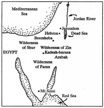
Kadesh appears to have been the Israelites’ main base during their forty years in the wilderness. It was the place where the twelve spies reported to the people after their fact-finding mission to Canaan, and where Moses planned the final journey to Canaan about forty years later (Num 13:25-26; Num 14:32-34; Num 20:14-21). Little is known of events at Kadesh during the intervening years. Two recorded incidents were Miriam’s death and Moses’ striking of the rock in search of water (Num 20:1-14; Num 27:14).
Moses intended that after the conquest of Canaan, Israel’s southern border would run from the Dead Sea through Kadesh-barnea to the Brook of Egypt, which it would follow to the Mediterranean Sea (Num 34:1-5). Though Israel’s conquest reached Kadesh, the town that later generations usually recognized as marking Israel’s southern border was Beersheba, almost fifty kilometres to the north. The wilderness of Zin lay between the two towns (Jos 10:40-41; Jos 15:1-3; 2Sa 17:11; 2Sa 24:2).